We exclusively revealed last month that Apple is developing its own mapping database, complete with 3D Street View imagery – and the company has now officially confirmed this on a new webpage.
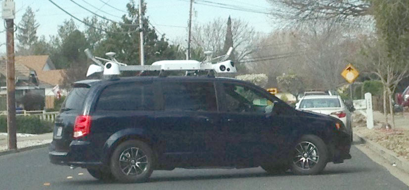
Apple is driving vehicles around the world to collect data which will be used to improve Apple Maps. Some of this data will be published in future Apple Maps updates.
We are committed to protecting your privacy while collecting this data. For example, we will blur faces and license plates on collected images prior to publication.
We first speculated back in February that this was the likely reason for the camera-equipped minivans leased by Apple, at a time when many were suggesting they were test beds for self-driving cars.
If you fancy trying to photobomb one of Apple’s camera vans, the company has posted a list of the locations they will be visiting later this month …
As well as thirteen locations in the U.S., Apple vans are also visiting four regions in England, plus Dublin and surrounding areas in Ireland.
Apple Maps has so far relied on third-party mapping data, the bulk of it supplied by TomTom. The famed Apple Maps glitches (some of them rather beautiful) were in large part the result of relying on automated processes to integrate mapping data from disparate sources.
Apple this week announced the addition of mass transit directions to Apple Maps as part of iOS 9.
FTC: We use income earning auto affiliate links. More.


“the company has posted a list of the locations” – where is the list?
In the link to the Apple webpage.
huh… no Portland on this list? weird…
Looking at Apple’s plan for mapping England, it does look as though their current plans are to merely produce street level views of only a few relatively heavily populated areas. They don’t say how many cars will be deployed, but looking at Apple’s list of planned areas scheduled to be visited over a 14 day period, they’re not going to be able to do any in-depth mapping. Apple’s list does remind me of those tourist coach tour schedules where they visit the well known attractions of an entire country in just one afternoon.
A key aspect of Google’s street view is that they provide detailed views of even small villages in far away countries. Apple needs to find the resources to adequately map entire nations in detail, because otherwise the limitations of their coverage will make it largely impractical and there is a danger that Apple Maps will attract a lot of derogatory comments again.
It’s always going to make sense to start with the most heavily-populated areas. I’m sure coverage will be expanded over time.
Google didn’t map the world in 14 days (they used external data for years), and the don’t drive around constantly.
Street View from my home town is at least 5 years old.
Apple is so far behind in this game its a lost cause. This will be flyover 2.0 a few select locations so rendered useless by 99% of travelers.
Why not use drones?
Ask Apple, Flyover is beyond pointless when its limited to a handful of locations. This new Apple streetview will be the same way for 5 years at best. This project is so buzz lines like “revelutionary real street level imagery” can be used in WWDCs down the road. No real plan to mass implement. We only just now get transit don’t expect to use this streetview in real world application before 2020.
Maybe someday they will, but depending what you are doing and where you may still need to apply for permits and the like to fly them around a city, and the whole thing may not end up being substantially easier than throwing gear on a helicopter.
I just saw this van drive through my neighborhood in Lake Stevens Washington yesterday. I took a picture while it was driving away: https://www.facebook.com/photo.php?fbid=10205623509019022&l=2e9f8e65da
Spotted today rte 128/95 south between Burlington and Waltham Massachusetts during rush hour 815am
I wonder if Apple has outsourced some of the image collection work to Google. I’ve seen loads of street view cars in London recently, never seen them here before, but it matches with Apple’s time frame of collecting imagery.