
Apple Maps

See All Stories

When the iPhone first launched, it was preloaded with Google Maps. In 2012, Apple replaced it with its own mapping application known as Apple Maps. It launched in beta in the iOS 6 beta, and was released to the public that fall.

After its launched, it was clear that it was no on the same level of quality as Google Maps. The poor launch led to a public apology from Tim Cook and ultimately led to the firing of Scott Forstall.

Apple Maps Features

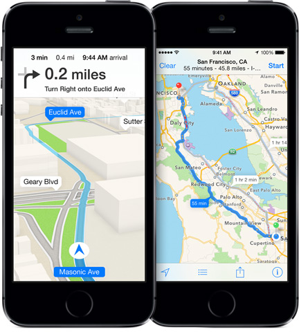
Over the years, Apple has continued to adds features to Apple Maps. iOS 11 brought lane guidance and a speed limit widget on the navigation, and indoor location mapping.

Apple has also added proactive location suggestions (time to get home when you are leaving work, etc), integration with public transit, Yelp integration, and integration with ride sharing services like Lyft and Uber.

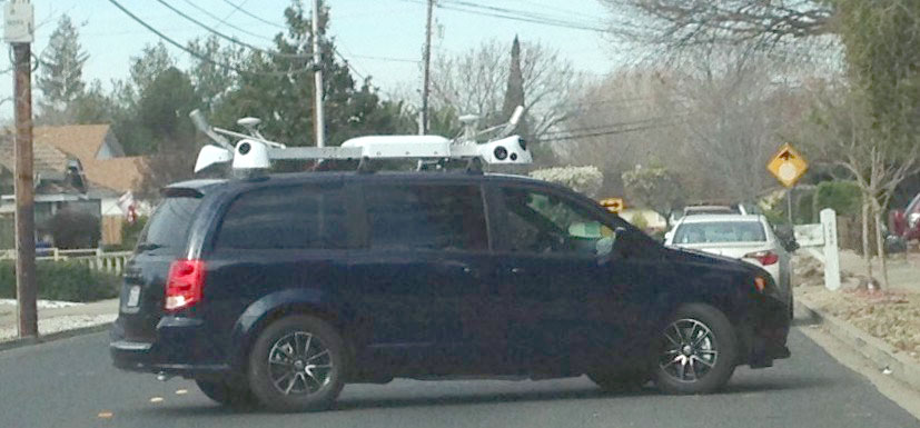
With iOS 12, Apple has proclaimed they are rebuilding Maps from the ground up.

Maps is being rebuilt from the ground up to better reflect the world around you. The new underlying map uses Apple data and features enhanced geographic context like pedestrian paths and parks, more detailed building outlines and parking lots, better road network coverage, and more. You’ll also be able to get where you’re going with improved routes, whether you’re on the road or on foot. The new Maps is now available in Northern California and is coming soon to the rest of the United States.

While the general consensus is that Google Maps offers more accurate data and navigation, Apple Maps is widely considered to be the most used mapping application in the world since it’s built into every iPhone, iPad, and Mac.

Apple might have accquired GPS company Coherent Navigation to bolster Maps accuracy (Update: Apple confirms)

Site default logo image

Update: Apple confirmed the acquisition.

Apple, which has already acquired a variety of companies to help its Maps team, appears to have recently purchased San Francisco-based GPS company Coherent Navigation. The company was founded in 2008 by a pair of engineers from Stanford and Cornell. While Apple and Coherent Navigation have yet to confirm the acquisition, several pieces of evidence support the idea.


Expand
Expanding
Close

Apple Maps Connect travels to five additional European countries

Site default logo image

Apple this week has expanded its Apple Maps Connect service to five additional regions in Europe: Austria, Sweden, Denmark, Belgium, and The Netherlands. The additions were noted in an email to users of the platform and on the Apple Maps Connect website. For those unfamiliar, Apple Maps Connect allows business owners to both manage existing Apple Maps listings and add additional listings to the platform. This service works closely with the Apple Indoor Mapping feature, which aims for businesses to help Apple build up a portfolio of indoor mapping data. Apple earlier expanded Apple Maps Connect via service updates in January, February, and MarchThanks Chris!


Expand
Expanding
Close

Tour the Arches National Park on Apple Maps Flyover, plus 19 other locations

Site default logo image

Apple is adding 20 new Flyover locations to Apple Maps, including the Arches National Park in Utah. Flyover not only provides a great way to get a realistic view of a location, but also allows some virtual tourism of some of the bigger sights out there that you may never get the chance to visit in person.

As always with Flyover updates, it can take a little time for them to roll out to everyone. You’ll know it’s available when you search for a location and see the Flyover bar with its Start button … 
Expand
Expanding
Close

Nokia wants Apple to buy its struggling HERE Maps division

Site default logo image

According to a report from Bloomberg, Nokia is targeting Apple as a potential buyer for its maps business. Nokia has recently been trying to sell its HERE Maps division due to it losing revenue. The report claims that Nokia is seeking around $3.2 billion for its maps business. Nokia first bought the mapping assets in 2008 for $8.1 billion.


Expand
Expanding
Close

Site default logo image

Small business owners in USA can now claim points of interest in Apple Maps within iOS app

Apple started allowing local businesses to add or manage their listing in Apple Maps back in October of last year, but this had to be done through the Maps Connect web service. As of today, it can be done directly through the Apple Maps app on an iOS device running the latest iOS 8.3.

To claim your business, search for it in the app, tap the Info icon, select Report a problem and then select Claim this business at the bottom of the screen.

Businesses in selected other countries can still claim their business through Maps Connect, which was expanded from the US to Australia, New Zealand, Ireland, Singapore and the UK in January; to Canada, France and Germany in February; and to Italy, Switzerland and Mexico in March.

Apple wins patent for Maps feature that could help you avoid routes w/ weak cellular signal

Site default logo image

Apple applies for and gets awarded patents for everything under the sun, and patents don’t always translate to shipped features. Disclaimer aside, the iPhone maker was recently awarded a patent for a potentially useful feature that could help you avoid areas with weak cellular coverage when planning your trip with navigation in Maps.

The USPTO awarded Apple with a patent (via Gigaom) to analyze routes between two locations and “employ an algorithm that considers wireless network signal strengths along those routes.”

In other words, because your iPhone can collect and measure cellular signal data and many iPhone users anonymously share travel data with Apple, there’s potential for Maps to know which routes problematically contain dead zones and suggest lengthier routes with better signal.
Expand
Expanding
Close

Apple Maps adds animated 3D imagery starting w/ UK’s London Eye & Big Ben (Videos)

Site default logo image

Apple has added some nice new touches to Apple Maps with animated 3D imagery for iconic landmarks starting with the UK. Apple Maps now shows the correct time on Big Ben and a rotating London Eye when users viewing the landmarks access the app’s 3D Flyover feature.

Videos showing off the animated London Eye and Big Ben in Apple Maps are below:
Expand
Expanding
Close

Site default logo image

Apple adding 9 new 3D Flyover locations to Maps

Apple today added nine new cities to its Flyover feature offering high resolution 3D imagery of select locations in its Maps app.

The full list of new locations rolling out is below:

Baton Rouge, LA
Boise, ID
Edinburgh, Scotland
Cáceres, Spain
Guadalajara, Mexico
Ponce, Puerto Rico
Venice, Italy
Linz, Austria
Rennes, France

The new additions follow Apple’s latest update last month that added another 11 cities from locations around the world.

As always, Apple has a full list of supported locations for iOS features including Flyover on its website.

Site default logo image

Apple Maps Connect gains new languages as it expands to Canada, France & Germany

The Apple Maps Connect service, which allows small businesses to add their listings to the Apple Maps database, has been expanded to Canada, France and Germany. The service has also gained two new language options, French and German, to correspond with the regional expansion.

Apple first launched Maps Connect in the U.S. last October, enabling businesses to edit or add listings, as well as set up indoor mapping within selected areas. Entries made by businesses typically show up in Apple Maps around a week later. The international rollout began last month with the UK, Australia, New Zealand, Ireland and Singapore.

Apple switched from Google Maps to its own mapping service on iCloud.com in December. Apple-leased camera cars have been spotted recently, with some suggesting that they are being used to add Street View style images to Apple Maps, while others believe they are part of the Apple Car project.

Site default logo image

Apple Maps Connect for small businesses expands beyond the U.S.

Apple has notified Apple Maps Connect for Small Businesses users that the service has expanded beyond the United States into the U.K., Australia, New Zealand, Ireland, and Singapore. As we detailed in October of last year, Apple Maps Connect is a web-based tool for businesses to either add or edit their listings to the Apple Maps database. The site is also used to bolster Apple’s indoor mapping data for future iOS Maps features. Thanks, Matt!


Expand
Expanding
Close

Site default logo image

Dutch city of Rotterdam gets the 3D Apple Maps imagery and Flyover [Update: Strasbourg & Malmö too]

[youtube=https://www.youtube.com/watch?v=m1OHRoEjL6Q]

Apple Maps has brought 3D imagery and a Flyover tour to the Netherlands for the first time, with Rotterdam leading the way. The second-largest city in the country, and home to one of the largest ports in the world, Rotterdam may have been selected for the proliferation of funky architecture.

Dutch site iculture put together the above video of the Flyover tour, which highlights among other places the Euromast tower – a popular tourist attraction – the Erasmusbrug single-sided suspension bridge and the famous (and very cute) Kubuswoningen cube houses.

Update: Strasbourg in France and Malmö in Sweden just got added too (via iGen).

Apple recently added nine other Flyover locations around the world, and switched from Google Maps to Apple Maps for the Find My iPhone service on iCloud.

Did Apple drop Google Maps for good? Apple Maps now rolling out on iCloud.com

Site default logo image

Apple appears to have finally dropped Google Maps from iCloud.com, replacing it with its own in-house maps almost two years after removing Google Maps from iOS and most of its other products. Apple started slowly rolling out the feature to its iCloud beta site for select users earlier this year before pulling it, but it now seems to have replaced Google for all users of iCloud.com’s Find My iPhone feature (pictured above).
Expand
Expanding
Close

Apple launches new service allowing local businesses to get listed on Apple Maps, solicits indoor mapping partners

Site default logo image

Apple has launched a new web service called Maps Connect that allows small business owners to manage their listings on Apple Maps along with a tool for setting up indoor positioning in select areas. Companies can enter their own listings and verify via a phone call or email address.

The iBeacon-powered indoor mapping tool allows businesses to setup interior views of their businesses on Apple Maps to help guide users through their venues. This tool is currently limited only to locations that meet specific criteria, such as Wi-Fi throughout the building and at least 1 million visitors per year.


Expand
Expanding
Close

Apple hints at Maps data-collection project taking place in New York

Site default logo image

Apple has for a long time hired engineers around the globe to contribute to making its Maps experience better. While positions for its team outside Cupertino usually consist of Maps Quality Analysts and Ground Truth managers that submit region specific corrections for Maps, a new job listing on Apple’s website hints at a “data-collection project” planned for New York.
Expand
Expanding
Close

UK carrier reports increased Apple Maps usage as ComScore numbers show downward trend

Site default logo image

Apple’s Maps app, introduced as part of iOS 6 in 2012, has had its fair share of technical issues and was the source of a PR crisis and the ejection of multiple long-time Apple executives. But two years later, if data from UK carrier EE is any indication, Apple Maps usage appears to be on an upward trend. Here’s the latest usage data for Apple Maps from the network:


Expand
Expanding
Close

More on why public transit directions got lost in iOS 8 Apple Maps

Site default logo image

TechCrunch is out with a story today with details on why some of the mapping features originally scheduled for iOS 8 didn’t make the cut at Apple’s WWDC keynote last week. The report quotes a few sources close to the mapping teams that say most of the improvements originally planned for iOS 8 weren’t finished on time due to talent departures and internal politics:

Why didn’t they appear? One tipster says it was a personnel issue: “Many developers left the company, no map improvements planned for iOS 8 release were finished in time. Mostly it was failure of project managers and engineering project managers, tasks were very badly planned, developers had to switch multiple times from project to project.”… It’s a take that is both contested and corroborated by our other source. “I would say that planning, project management and internal politics issues were a much more significant contributor to the failure to complete projects than developers leaving the group,” the source said.

We reported leading up to WWDC that the transit directions in iOS 8 might be pushed back to instead focus on other priorities.

While the TechCrunch report doesn’t mention any names, we do know that the mapping team has lost a few key people recently. Back in March, reports popped up that Cathy Edwards, who happened to be in charge of Maps Quality after joining Apple through the company’s acquisition of Chomp, was leaving the company. The reason behind Cathy’s departure was unknown at the time, but we’ve learned from sources that disagreements with employees on the Maps team working under Edwards and an opposition to her management style lead to problems on the Maps team and ultimately her leaving in April. Apple also lost key Maps team member Jared Waldman from Placebase who worked as Head of Geo at Apple Maps until late last year. In addition, we’ve heard from former employees of the mapping team that recently left the company due to issues with Edwards and management of the Maps team. 
Expand
Expanding
Close

Site default logo image

Apple hires CEO of indoor positioning firm Wifarer as it continues testing indoor mapping features

TechCrunch reports today that the CEO and founder of Wifarer, a company working on innovative indoor positioning technology, has has left for a leadership role at Apple.

If a CEO and co-founder quits his indoor positioning startup to work for Apple, should his staff and customers be concerned? Wifarer, a startup which offers tools to help consumers navigate malls, museums and other venues, was notacquired by Apple, we learned, while following up on some tips pointing in that direction. However, its CEO and founder Philip Stanger now works there in a “leadership role.”

While Philip Stanger confirmed on his LinkedIn that he’s been at Apple since February, the report notes that the company claims it is still in business and has not been acquired by Apple:

And finally, it’s odd because despite new CEO Murphy’s claims, Wifarer could be seen as being in decline. The company got rid of its sales staff in 2012, and today there are roughly a half dozen employees still at the company, according to what we’ve heard, as well as public searches on LinkedIn. Murphy says its numbers are higher than that, but admits they’re less than Wifarer’s previous peak.

We’ve reported several times in the past that Apple is working on new Maps features that would rely on indoor positioning technologies. Ahead of  iOS 8, Apple is currently testing unique ways of integrating indoor mapping views into its Maps app, but those features aren’t confirmed for the next iOS release.

Last year, Apple picked up another company working on indoor positioning technologies called WiFiSLAM.

Site default logo image

Apple Maps adds ancient Stonehenge monument to 3D Flyover

Nobody is quite sure why or how Stongehenge was constructed, but the stone circle constructed sometime between four and five thousand years ago has long fascinated visitors.

As a Scheduled Ancient Monument and a UNESCO World Heritage Site, the closest most visitors can get to it these days is a pathway around the outside. (I probably shouldn’t admit this, but as a young child who lived nearby before all the restrictions were put in place, I used to climb on the stones …)

But thanks to Apple adding the site to its 3D Flyover library of Apple Maps, you can now take a tour around the site from the comfort of your sofa. Just enter Stonehenge into the search box.

Apple added 3D Flyover coverage of Perth, Saint-Tropez and Cordoba last month. This followed Cape Town, Helsinki and Marseille back in January. After a less than stellar start, Apple is working hard on an upgraded version of the Maps app ready for iOS 8.

Will CarPlay impact your next car purchase? [Poll]

Site default logo image

After Mark uncovered it last April and Apple announced it last June, this week we’ve seen a steady stream of details about Apple’s iOS and car integration following Apple’s marketing push. There’s plenty more coverage on the way as we continue to explore what CarPlay means for Apple and its users, but now we want to hear from you. What effect will CarPlay have on your next car purchase?

Cars certainly aren’t purchases you make impulsively (or often), and CarPlay seems to address that by relying on the iPhone (something we may purchase impulsively and often) for much of the functionality. Among other things, will CarPlay be on the list of things you look for in your next car purchase?
Expand
Expanding
Close

Apple explores customizable layers for future Apple Maps app – new patent application

Site default logo image

We’re pretty selective in the Apple patent applications we cover here, simply because Apple patents all kinds of things for all kinds of reasons, and for every one of them that makes it into an Apple product, there are hundreds of others that never will. But this is one we think might.

The core concept is nothing new: layered maps. The existing Apple Maps app already allows us to choose between standard mapping, satellite view or both, and Google Maps on the web allows us to switch on or off layers like traffic, weather, public transit lines and so on. But what the Apple patent application describes would, if you’ll excuse the pun, take this idea to a whole new level … 
Expand
Expanding
Close

Site default logo image

Google Maps iOS app gets some Google Now functionality, showing reservation info

The latest version of the Google Maps iOS app has been given some Google Now functionality: when you click on an airport, hotel or restaurant, the app will display any reservation information it can find in your linked gmail account. This functionality was previously only available in the desktop app.

Although Google has added a succession of features to the app, data last month showed that most iPhone users were using the pre-installed Apple Maps. Adding Google Now functionality is an attractive feature for gmail users, but Google faces the same problem as ever since Apple replaced Google Maps with its own offering: most iPhone users will use what Apple gives them.

Google Maps is a free download from iTunes.